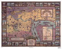
The best 70-year-old map of Shanghai
 BEST OF SHANGHAI: ‘One man’s opinion’
I’ll keep this short, because I know that, like me, you are all probably rushing around doing your last-minute Chinese New Year shopping. Wait a minute — this thing I’m writing about would actually be a perfect gift. I mean, what is better to hand out on the most important of Chinese holidays than a historic Shanghai map from a time when most of the city’s streets had French names? Better yet, what if that map was created by an American who helped establish the Nationalist government?
I know what you’re thinking: Dan, this actually sounds like a much better gift for Valentine’s Day. And — you know what? — you’re right. What says I love you better than an old map? “Baby, I was lost until I found you …” — the card really writes itself! This map would never fit in one of those Spring Festival red envelopes anyway.
Failed attempts at humor aside, this 70-year-old map — brought back to life in limited edition form by longtime Shanghai resident and author Paul French — would be a great gift, during any time of year, for a Shanghai history buff or any resident of Shanghai. It also may dispel some longstanding urban myths about that “former swamp” we know as Pudong.
“The Municipal Council’s map, issued for visitors to Shanghai in 1935, shows a city that had grown up in the previous 20 years — by 1935 the Bund was formed pretty much as we know it today and the International Concession reached out past the race course, now People’s Square,” French said. “One interesting thing to note is that when supposed old hands in Shanghai tell you Pudong was nothing but fields and farms when they came here you’ll know they are bullshitting — the map shows how Pudong was a thriving factory area then around what is now Lujiazui.”
01.30.2005, 6:00 PM · Best of Shanghai · Comments (9)
